I’ve been doing a lot of training down at Clark Gully (part of High-Tor DEC area in Middlesex, NY) recently and the number of folks who’ve wanted to come with or learn more about the trails there has been growing pretty rapidly. Thing is, there are no marked trails and no known maps of the area. It’s a space you just have to go and get lost a bunch of times and sort it out for yourself.
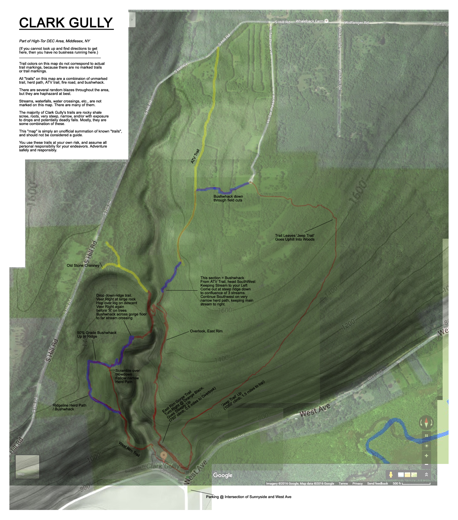
After much request, I finally overlayed a bunch of my Strava data onto some topo screenshots of the area and put together a rough “map” that folks can use to stumble their way around, if interested. This shouldn’t be mistaken for a guide, and there’s still a lot of guess work involved. Be sure, these trails are not to be taken lightly. (Download link appears below.)

Disclaimer: This “map” is to be used at your own risk. Mountain/Trail running, particularly on terrain such as the “trails” through Clark Gully, is inherently dangerous and carries with it varying degrees of risk ranging from injury to death. Please be aware that by downloading this map and participating in these activities, you do so at your own risk. I bear absolutely no liability for your actions. You are encouraged to always adventure within your own limits, ability, knowledge, judgment, and experience. Keeping informed of current conditions and exercising common sense are the keys to a safe and enjoyable outing. I assume no responsibility whatsoever for any risk or injury that you may incur as a result of consuming information from my site and/or social media network(s). By downloading this document, you assume all responsibility for your own actions.
LINK: CLARK GULLY MAP DOWNLOAD
[…] Since this report, I’ve released a “Clark Gully Map” of sorts. You can check that out and download it here. […]
This is incredibly awesome! Thanks! I can’t believe they don’t have any trail maps available, but you’ve helped fill a void.
What you call a “jeep trail” is actually an old abandoned road, which can be seen in the 1903 USGS topo map for the Naples Quadrangle, NE corner:
http://docs.unh.edu/nhtopos/Naples.htm. It continues up to Wickam Rd, but looking at Google maps there is a short section that is now private property toward the top. You can see the abandoned road in Google Earth if you go to the historical May 2007 view.
I am a slow, plodding hiker that goes even slower on steep hills, so your map will help me make it out in less than a day 🙂
April, I’m so glad this is of help! There aren’t many folks who go down and explore Clark Gully, but those of us who do are fortunate to have had the experience. Such an incredible area! Have fun!! (And thanks for the piece of history – fascinating!)